HIKE: Tongariro Alpine Crossing, North Island, New Zealand
WHEN: April 2016
LENGTH: 12.1 miles, one way
DIFFICULTY: Challenging
FEATURES: Barren volcanic landscape; craters; fairly high altitudes; native plants; geothermal steam vents; emerald water-filled explosion craters; can be windy and chilly, even in the fall; restrooms at a few spots along the trail; well-maintained; very crowded.
It all started with a simple question: “What do you want to do tomorrow?”
This began a Google search that ended with this suggestion from my husband: “How about the Tongariro Alpine Crossing?”
This was the conversation just before dinner the night before we decided to get up early and make the 12-mile trek across a barren volcanic landscape in the Tongariro National Park, the oldest in the country. The crossing considered one of the Top 10 best hikes in the world and takes between six and eight hours to complete.
But hiking it isn’t as easy as just showing up to the trailhead.
There’s a lot to consider, such as the weather — it can be windy and extremely cold — and terrain — you need sturdy hiking shoes. You’ll be walking at elevations above 5,000 feet and much of the trail is uphill. Neither of us had packed for serious hiking. I only had yoga pants and jeans — not the best hiking gear — and zero-include walking shoes. This would be a problem.
Then there’s the transportation.
The trek requires securing seats on a shuttle that takes you to the start of the trail (Mangatepopo). You can book these from Taupō, where we were staying about 65 miles north of the national park. Or you can park at the end — at the Ketetahi Car Park — and catch the shuttle to the start, about 20 minutes away. We booked the latter with Adventures HG at $30NZD per person.
The night before, we gathered whatever gear we could muster, picked up essentials (beef jerky, granola bars) from the nearby convenience store, and planned to meet the shuttle at the car park at 7 a.m. (That required us getting up at 4:30 a.m. to drive to the national park.)
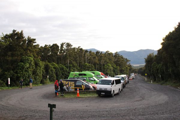
7 a.m. at the Ketetahi Car Park.
After reading reviews online, we anticipated the trail would be crowded. It’s easily one of the most popular treks in New Zealand, with more than 10,000 people braving the crossing every year. So we planned to get to the car park early, around 6:45 a.m., to ensure parking.
But by the time we got there, the small parking lot was already full and we wound up finding a spot on the dirt road instead.
Most of the trekkers were younger than us, Europeans and Kiwis, most on holidays and some on extended month-long vacations. I rode on the shuttle with a young German college graduate who left Europe to travel around New Zealand for four months. “All my friends are doing it,” she said, beaming. Already, she had learned to surf and had hiked for the first time. This trek would be her second hike. Ever.
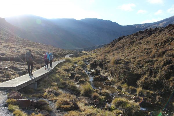
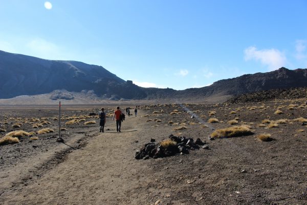
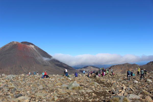
The start of the trail at Mangatepopo was a madhouse, with dozens of people jumping out of shuttles and hitting the trail. Some stood in line at the last restroom for a mile; others rushed down the boardwalk to snap photos or just beat the mob.
The start of the crossing at Mangatepopo.
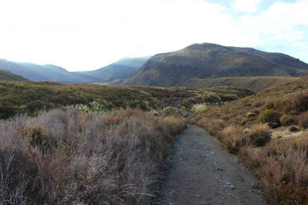
This trek is one of the best maintained trails we’ve ever hiked.
It was a gorgeous day for a hike.
We hit the trail at around 8 a.m. I was wearing the following: a tank top, a long-sleeve tee, a high-altitude base layer, a wool pullover, a heavy-duty rain jacket and a scarf. That was just on top. On the bottom, I had my yoga pants under a pair of jeans — and two pairs of socks. I couldn’t feel the chill at all.
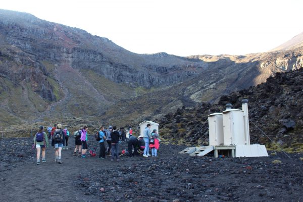
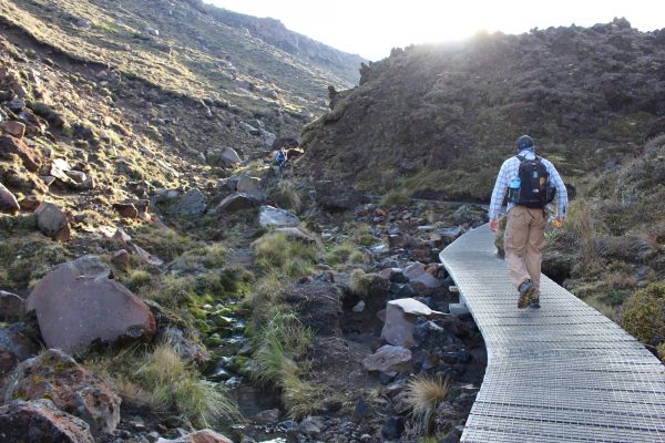
The second restroom at the Mangatepopo Hut.
We trekked over layers of ancient and modern lava flows and other volcanic deposits, which made this part of the trail even more difficult.
The section known as the Devil’s Staircase.
But it was a bit nippy. I needed all of those layers. At least during the first half an hour of walking. By the time we had reached the Mangatepopo Hut — where the restrooms were — we had shed most of our layers. The mid-morning sun — with no clouds in the sky — was already beating down on us. We even had to put on sunscreen.
The next part of the trek was the hardest: It’s called the Devil’s Staircase for a reason. It’s a steep climb, from 4,600 feet to 5,200 feet above sea level. And it’s brutal, especially with the elevation change. This is where hikers started to slow down or stop completely for water breaks.
And it was worth stopping, too, especially for the views. On this clear morning, we could see down the valley and out across the surrounding countryside. We could even see Mount Taranaki in the west.
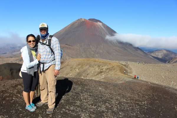
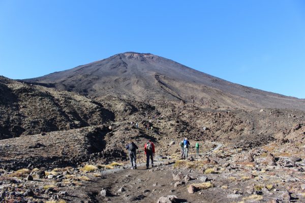
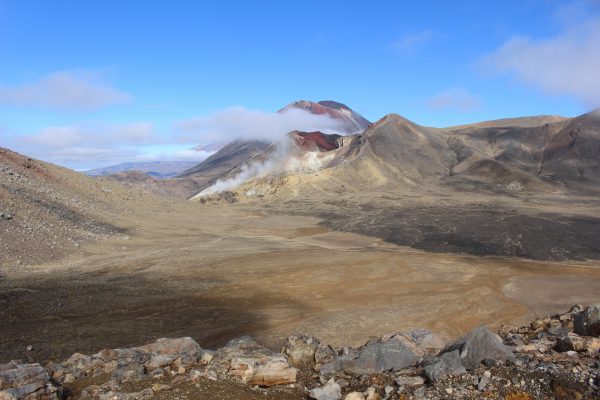
Most impressive, at least to us, was the sight of Mount Ngauruhoe, more commonly known as Mount Doom in the Black Land of Mordor from “The Lord of the Rings” trilogy. This stratovolcano rises 7,516 feet above sea level and is made from layers of lava and tephra. It first erupted about 2,500 years ago, and it’s still active today.
There’s a three-hour, round-trip side hike to the summit. We stuck to the trail.
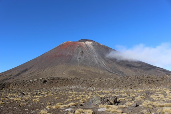
Mount Doom, otherwise known as Mount Ngauruhoe.
It took us about an hour to get through this uphill section before arriving at the flat path between South Crater and Red Crater. It was a nice reprieve, though it didn’t last very long. Before we knew it, we were climbing up the side of Red Crater to an exposed ridge, which encircled it. This part was challenging — though the worst was over — and tiring.
The flat section between South Crater and Red Crater.
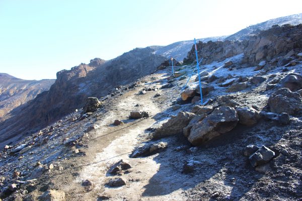
The trail leading up to the rim of Red Crater — and look, there’s frost!
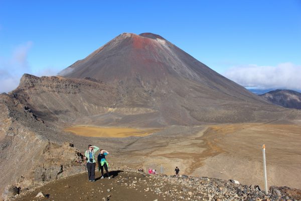
We lucked out with these perfect views of Mount Ngauruhoe.
A lot of hikers opted to stop here, eat lunch and take in the view.
The descent from Red Crater wasn’t as easy as it sounded. The loose scoria (a lightweight, dark-colored igneous rock) moves quickly and easily, making the downhill trek slippery and dangerous.
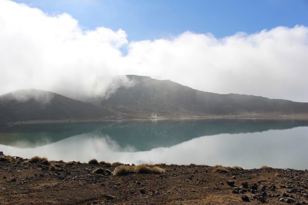
But the reward is this: three water-filled explosion craters called the Emerald Lakes.
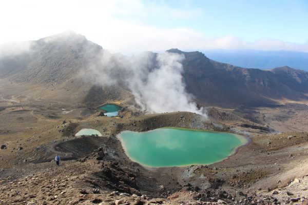
Behold the Emerald Lakes.
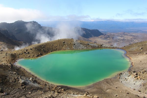
The brilliant green color comes from minerals such as sulfur leaching from the adjoining thermal area.
Mount Ngauruhoe in the distance behind us.
These lakes get their color from the minerals such as sulfur leaching from the adjoining thermal area. Its Māori name is Ngarotopounamu, meaning “greenstone-hued lakes.”
The water is highly acidic and the lakes freeze over in the winter.
The steam vents in the area produced a sulfuric stench that shortened our stay here.
The Blue Lake, the final lake on the hike and the start of the downhill trek.
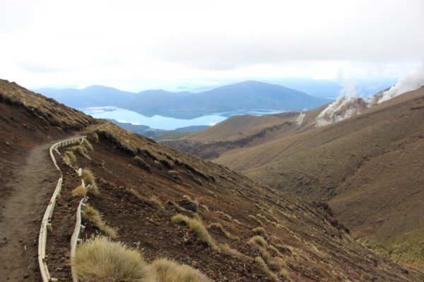
After the Emerald Lakes, we walked across another barren volcanic flat and around the rim of an old crater filled with water. This is Blue Lake, or Te Wai-whakaata-o-te-Rangihiroa, which translates to “Rangihiroa’s Mirror.” It’s kapu (tapu in Māori), or sacred, and no one is allowed to swim in or eat food around this lake.
The long descent.
The zigzag down to the Ketetehai Hut.
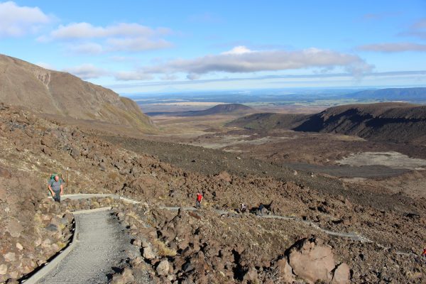
Blue Lake marks the beginning of the end — though the end isn’t that close.
It would take another hour and a half down the switchbacks that lead out of the crater and into the rainforest where our cars were parked.
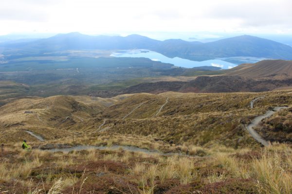
The views of lakes Rotoaira and Taupō to the north from the trail are absolutely stunning. We walked through golden tussock-covered slopes, zigzagging across the mountain, past the final rest stop at Ketetahi Hut and into a thick padocarp-hardwood forest full of native plants. Here, the temperature dropped a bit, thanks to the tree canopy and flowing streams. I actually put my rain jacket back on.
It’s a long descent from 6,188 feet at Red Crater to 2,490 feet at the car park. And by the last half an hour, I was ready for this part of the trail to end.
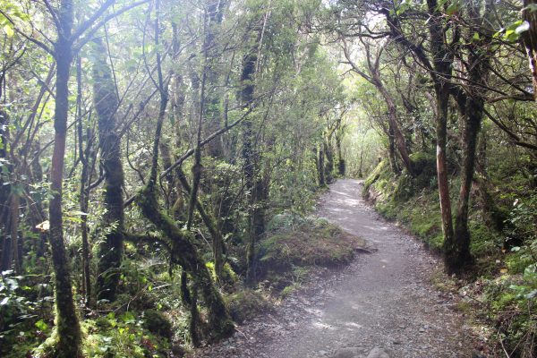
The forest here reminded us a lot of the ones back home in Hawai‘i.
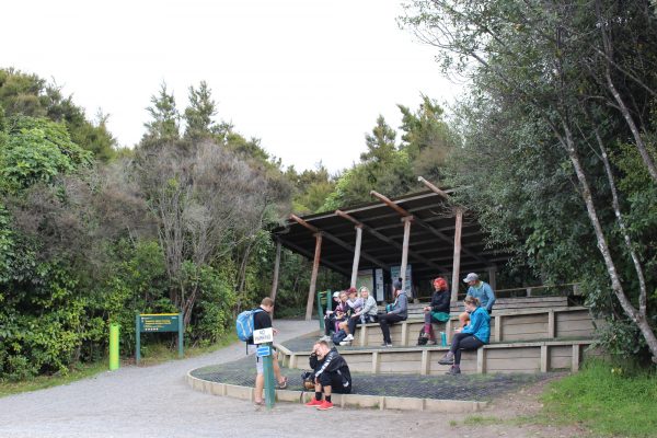
The end!
We made it to the end of the trail, where only a handful of people were waiting for shuttles back to the city. It took us five and a half hours — about two hours faster than what we had planned for — and we were both ready for a glass of wine.
Or maybe several.
VERDICT: It’s easy to see what the Tongariro Alpine Crossing is considered one of the best treks in the world. The scenery is breathtaking, from steaming vents to peculiar moonscape basins to the majestic Mount Ngauruhoe. I’m just glad we had good weather: In poor conditions, this would be just an arduous uphill battle, absolutely no fun at all. You should be in reasonably good fitness to make the crossing and fairly well prepared, including wearing good hiking shoes. (Ask my feet about that.) Nice summer days can see more than 1,000 people on the trail at once, so plan accordingly. But definitely plan on it.
***
Follow my adventures in New Zealand on Instagram (@catherinetoth), Twitter (@thedailydish), Facebook (/thecatdish) and Snapchat (@catherinetoth). #cattravels


3 Comments
Your adventures in New Zealand are so interesting especial this hike and the amazing photos. Thanks for sharing it with us.
Thanks, Ann, for reading and glad you enjoyed! I haven’t seen many very comprehensive overviews of this hike, so I thought I would contribute to the information that’s out there! 🙂
Hello Cat! That was an amazing hike! Thank you for sharing.